The entrance to Arches National Park is just off U.S. Highway 191, a few miles north of Moab, Utah. Between the park entrance and Moab is the junction of U.S. 191 and Utah State Route 128. From the junction, U.S. 191 goes northwest, while Utah 128 goes northeast, both of them eventually connecting to Interstate 70. Most of Utah 128 follows the Colorado River on its east side. About 30 miles north of its southern end, the road goes over a bridge and onto the west side of the river. After a few more miles, Utah 128 and the Colorado part company, with the road proceeding northward across a relatively flat area before coming to a T. Turning left keeps you on Route 128 and after a few more miles, takes you to I-70. Turning right puts you on an unnumbered road which also goes to I-70, after passing through the remote town of Cisco.
Much of Route 128 along the Colorado is in a canyon. There are also some rock formations along the road, such as these, about two miles south of the bridge.
The bridge itself is a replacement for an earlier suspension bridge, called the Dewey Bridge. Its remains can be reached via a short side road near the modern bridge. This is the tower on the east side of the Colorado.
This marker indicates that the Dewey Bridge has been placed on the National Register of Historic Places.
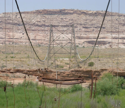
Standing under the east tower, I could see the west tower and the remaining cables.
After crossing the modern bridge and continuing northward for about two miles, I came across this rock marked with Indian petroglyphs and some modern graffiti. There was no road sign about "Indian Writing" or anything else. The stone simply caught my eye.


No comments:
Post a Comment